Table of Contents >> Show >> Hide
- What Exactly Is Tornado Alley?
- Why Chase Tornadoes at All?
- The Tools of a Tornado Intercept
- How Storm Chasers Actually Intercept a Tornado
- Safety, Ethics, and the Fine Line Between Science and Stunts
- How Storm Chasers Help You Stay Safer
- Experience on the Edge: What It’s Like to Ride Along on a Tornado Intercept
- Conclusion: Respect the Storm, Trust the Science
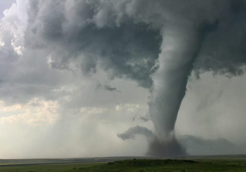
Somewhere on a lonely two-lane highway in Oklahoma, a boxy, armored truck
crawls forward while the sky turns the color of a bruise. Lightning flickers,
the wind shifts, and a rotating column of dust tightens in a nearby field.
Most people would stomp on the gas and get out of there. Storm chasers ease
off the throttle, check the radar, and calmly say, “We’re in position.”
That’s what an intercept looks like: getting close enough to a tornado to
measure it, without becoming part of the debris.
In the heart of Tornado Alley, these chasers blend meteorology, technology,
and frankly a surprising amount of common sense to approach one of the most
violent forces on Earth. This isn’t just thrill-seeking; their intercepts
help scientists understand how tornadoes form and help forecasters issue
better warnings that save lives. Let’s pop into the passenger seat and see
how they do it.
What Exactly Is Tornado Alley?
“Tornado Alley” isn’t a line on a government map; it’s a nickname for a
swath of the central United States where tornadoes most frequently occur.
Traditionally, this includes parts of Texas, Oklahoma, Kansas, Nebraska,
South Dakota, and Iowa, with some definitions stretching into Colorado,
Missouri, and even up toward Minnesota and Wisconsin. What these states
have in common is wide-open plains, warm moist air from the Gulf of Mexico,
cooler dry air from the Rockies, and strong upper-level winds that all come
together to build rotating supercell thunderstorms.
These supercells are the classic “anvil-shaped” storms you see in dramatic
storm photos. Their rotating updraft, called a mesocyclone,
is where tornadoes are born. Because the terrain in much of Tornado Alley is
relatively flat and the road network is decent, storm chasers can see storms
from long distances and maneuver around themtwo must-haves for a safe
intercept.
In recent decades, data show an uptick in significant tornado activity in
the Southeast, often dubbed “Dixie Alley,” but the central Plains still
remain the iconic training ground for storm chasers and tornado research.
Why Chase Tornadoes at All?
On the surface, storm chasing looks like pure adrenaline: racing after
rotating doom while yelling over the roar of hail. But behind those dramatic
videos is a serious scientific mission. Tornadoes are small, fast-evolving
features embedded in big storms. Weather radar sits miles away, so it
doesn’t always see the lowest part of the storm where the tornado actually
lives. That’s where storm chasers come in.
Many chasers work with or alongside research programs and the
National Severe Storms Laboratory (NSSL), which is part of
NOAA. Their goal is to improve the lead time and accuracy of severe weather
warnings by understanding how, when, and why tornadoes form and intensify.
That data feeds into models and warning tools that forecasters in National
Weather Service (NWS) offices use to issue tornado watches and warnings.
There’s also a huge volunteer component. Programs like
SKYWARN train local spotters (including some chasers) to
recognize storm structures and report what they seefunnels, rotating wall
clouds, debris, hail size, and wind damage. Those real-time “ground truth”
reports help confirm what radar is hinting at and can trigger or upgrade
warnings. In other words, storm chasers aren’t just chasing storms for fun;
they’re often a mobile extension of the warning system.
The Tools of a Tornado Intercept
There’s chasing, and then there’s intercepting. To get close enough to
measure a tornado, you need more than a pickup, a smartphone, and a full
tank of bravery. Modern storm chasers roll with an entire rolling weather
lab packed into their vehicles.
Armored Intercept Vehicles
You’ve probably seen them on TV: low-slung, wedge-shaped vehicles with
steel plating and tiny windows that look like they escaped from a sci-fi
movie. These are tornado intercept vehiclesheavily
modified trucks designed to get extremely close to tornadoes and, in some
cases, briefly park in their outer edges.
Examples include the original Tornado Intercept Vehicle (TIV), built from a
modified Ford F-350, and the SRV Dominator series, based
on armored SUVs and pickups. Extra steel, bullet-resistant glazing, and
reinforced frames help protect against debris. Many have hydraulic skirts
that drop to the pavement to reduce the chance of wind getting underneath
and flipping the vehicle. Inside, racks of computers display radar, GPS,
and data from instruments mounted on the roof.
Mobile Mesonets and Probe Teams
Not every chase vehicle is a tank. Many are
mobile mesonetsordinary-looking trucks outfitted with
specialized weather instruments on roof racks. These measure temperature,
pressure, humidity, wind speed and direction, and even solar radiation at
fine scales in and around storms. When several mobile mesonets drive
different routes around a supercell, scientists get a detailed picture of
the storm’s environment at ground level.
Then there are the probe teams. They deploy small, rugged weather stations
on the ground in the path of a tornado. These probes measure wind, pressure,
and other parameters inside the tornado’s circulation. Intercept
strategy often revolves around getting a probe into just the right spot
before the tornado crosses the road.
Mobile Radar: Doppler on Wheels
Among the most impressive tools are mobile Doppler radars, sometimes nicknamed
Doppler on Wheels. Think of a radar dish mounted on a
truck. By parking a few miles away from a tornado, mobile radar can scan the
storm at very high resolution, measuring wind speed and direction inside
the tornado and its parent storm. Combined with mobile mesonet and probe
data, these radar scans have produced some of the most detailed views ever
of tornado structure and evolution.
Projects like VORTEX2 (“Verification of the Origins of
Rotation in Tornadoes Experiment 2”) used fleets of these vehicles10 mobile
radars and around 70 instrumentsto intercept storms across the Plains. The
data from just a handful of tornado intercepts has fueled years of research
into how tornadoes develop and why some storms produce strong tornadoes
while others never do.
How Storm Chasers Actually Intercept a Tornado
Intercepting a tornado is much more like chess than drag racing. It’s all
about strategy, anticipation, and knowing when to bail out. Here’s how a
typical chase day in Tornado Alley might unfold for a professional team.
1. Targeting the Day
Long before anyone is dodging hailstones, chasers are hunched over morning
weather models. They study surface maps, upper-level wind charts, and
severe weather outlooks to pick a “target area” where conditions look best
for tornadic supercells. In Tornado Alley, peak season is usually from late
April through June, when warm, moist Gulf air regularly crashes into
cooler, drier air from the west.
The goal is to be in that sweet spot where instability (warm, buoyant air),
wind shear (changing wind speed and direction with height), and a triggering
boundary (like a cold front or dryline) all overlap. Miss that overlap by a
couple of counties, and you might spend the day under blue sky while storms
explode an hour away.
2. Choosing the Storm
Once storms form, chasers watch them on radar and visually from a distance.
They look for supercell signatures: a hook echo on radar, a persistent
rotating updraft, or a sculpted updraft base with a wall cloud. The best
chase is usually one where a single dominant supercell has plenty of space
to itself. Chasing messy clusters is like trying to play three chess games
at once in the back of a moving car.
Chasers maneuver to the southeast or east of the storm, where they can see
the updraft base and tornado without driving into the hail core or the
heaviest rain. Positioning is everything: too far away, and you can’t drop
probes or get high-resolution data. Too close, and you can’t safely
maneuver if the storm changes direction.
3. Setting Up the Intercept Path
When a tornado formsor a rotating wall cloud strongly suggests one is
imminentthe real intercept begins. The team estimates the tornado’s motion
and speed, then identifies a road that will cross its projected path at a
safe distance. They don’t chase into the tornado; they aim to get
slightly ahead and off to the side.
Armored vehicles may plan to stop briefly near the outer circulation, where
winds are intense but (in theory) survivable. Probe teams aim for spots just
upstream from the path, racing to drop instruments before the storm arrives,
then retreating at a safe angle.
4. Dropping Probes and Collecting Data
As the tornado approaches, probe teams pull onto the shoulder, place
heavy, low-profile instrument pods on the ground, and activate them. Data
starts streaming back to laptops in the vehicles or is stored on board
for later retrieval. Mobile mesonets keep rolling, measuring sharp changes
in temperature, pressure, and wind as they pass near the tornado’s inflow
region.
Mobile radars sweep the storm continuously, building a three-dimensional
picture of the circulation. Together, these measurements can reveal details
like how quickly wind speeds increase toward the center, how the tornado
interacts with boundaries at the surface, and how the parent storm’s
structure changes before and after tornadogenesis.
5. Getting Out Safely
A successful intercept is not just “we got the data”; it’s “we got the data
and everyone goes home.” Storm chasers constantly monitor new radar scans,
changes in the tornado’s appearance, and road options. If the tornado
suddenly widens, turns, or becomes rain-wrapped, they may abandon the
intercept entirely rather than risk getting cut off.
The tragic 2013 El Reno tornado in Oklahoma, which grew to 2.6 miles wide
and changed directions erratically, is a stark reminder of the risks.
Several experienced chasers were killed that day, and others barely escaped.
Since then, many in the storm chasing community have become more vocal about
safety margins and not underestimating a storm, no matter how familiar the
setup looks.
Safety, Ethics, and the Fine Line Between Science and Stunts
Intercepting tornadoes isn’t just about what you can do; it’s about
what you should do. Professional chasers constantly balance their
desire for better data with the need to stay out of the way of emergency
services and the public.
Training materials for spotters and chasers hammer home a few core rules:
- Never put yourself directly in harm’s way just to get a better view.
- Always obey traffic laws and instructions from public safety officials.
- Don’t block roads or driveways that emergency vehicles might need.
- Do not drive into flooded roads, debris fields, or low visibility.
In recent years, increased public interest in storm chasing (helped by
movies, TV, and social media) has led to more chasers on the roads. On big
tornado days in places like Oklahoma, it can look like a tailgate party
with rotating clouds. Professional chasers often worry about traffic jams
on rural roads and inexperienced chasers who may not recognize dangerous
changes in the storm. That’s why many scientists emphasize that intercepts
should be left to trained teams with solid meteorological knowledge,
reliable communication, and clear safety plans.
How Storm Chasers Help You Stay Safer
So how does a tornado intercept on a lonely Kansas road help someone sitting
at home in Missouri or Arkansas? It all connects through the warning system.
When chasers report a confirmed tornado, large hail, or damaging winds to
the NWS, those reports help forecasters decide whether to issue, upgrade,
or continue warnings. Even a short increase in warning lead time can give
families enough minutes to get to a safer place. Real-time video streams
and photosshared through official channelscan also help emergency managers
decide where to send resources after the storm.
Over the long term, intercept data feeds into the research that improves our
understanding of how tornadoes form and intensify. That research helps
refine radar algorithms, forecast models, and communication strategies so
that warnings are not just earlier, but more precise and more likely to be
trusted and acted upon.
Experience on the Edge: What It’s Like to Ride Along on a Tornado Intercept
Imagine climbing into a chase vehicle on a late May morning in central
Oklahoma. The back seat is crammed with tripods, hard cases, and a cooler
that has seen better days. Up front, two meteorologists argue (politely)
about which county line will be the “triple point” laterthe place where
warm, moist air, dry air, and a boundary all collide. Someone jokes that
lunch is “gas station cuisine with a 40% chance of regret.”
For the first few hours, it feels like a road trip with a weather obsession.
The sky is harmlessly blue. The team hops between weather model updates on
laptops and mobile radar apps on tablets, watching subtle shifts in wind and
humidity. You learn new vocabulary fast: CAPE, shear, hodographs, the
dreaded “cap” that can either kill storms or keep them bottled up until
they explode.
By mid-afternoon, the mood changes. Cumulus clouds start bubbling along the
dryline. One tower goes up higher than the others, glaciating into an anvil.
Someone points and says, “That’s our storm.” The vehicle turns off the
highway onto smaller roads, pacing the growing supercell. The cloud base
darkens, and you start to see the crisp structure that chasers dream about:
a striated updraft tower, a rain-free base, and a lowering where a wall
cloud forms.
The jokes taper off as the team starts speaking in quick, clipped phrases.
“Inflow’s strong.” “Rotation tightening.” “New scan shows a stronger couplet.”
Hailstones ping off the roof like thrown marbles, and the wind smells like
wet dirt and electricity. You can feel the inflow pulling warm air into the
storm, like standing near the intake of a giant, invisible machine.
When a funnel forms and stretches toward the ground, time seems to slow
down. The driver keeps a steady hand while the navigator calls out road
options: “Next east, then south, then we’ll be right on the track.” You’re
close enough now to see debris at the base, confirming that it’s a tornado.
The storm isn’t just an image on a screen; it’s a spinning column of wind
carving across fields that someone planted, past homes where people are
hopefully already in shelters.
For an intercept, the team picks a spot where a narrow, gravel road
intersects the tornado’s projected path, but at a distance that gives
escape options. A probe team jumps out, legs half-numb from hours in the
truck, and wrestles a heavy pod off the tailgate. The air is weirdly calm
and warm. Insects buzz. In the distance, the tornado growls like a freight
train wrapped in thunder.
They drop the probe, arm it, and sprint back to the truck. As you pull away,
you look over your shoulder and watch the tornado slide past the probe’s
position, swirling dirt and fragments of whatever it picked up along the
way. Inside the vehicle, the laptop lights up with live datapressure
plunging, winds spiking, speed and direction numbers rolling like the
world’s scariest slot machine.
It’s hard not to feel a rush. But there’s also a sobering undercurrent.
Every chaser has stories of close calls, roads that unexpectedly ended,
tornadoes that shifted direction, or debris that fell out of nowhere. They
talk about colleagues lost in past intercepts and remind each other that no
measurement is worth a life. As the storm weakens and the team turns back
toward town, radio chatter switches from tornado reports to damage reports
and requests for help.
That’s the full experience of a tornado intercept in Tornado Alley: part
science mission, part logistical puzzle, part roller coaster ride, and part
disaster-response preview. From the outside it looks like pure chaos. From
the inside, on a good day, it’s controlled risk in pursuit of knowledge
that ultimately helps keep more people out of harm’s way.
Conclusion: Respect the Storm, Trust the Science
Storm chasers who intercept tornadoes in Tornado Alley walk a narrow line.
They get close enough to one of nature’s most violent phenomena to measure
it in exquisite detail, but far enoughand smart enoughto live to chase
another day. Their work feeds directly into better forecasts, faster
warnings, and smarter building and preparedness decisions across the
country.
For most of us, though, the best place during tornado season is nowhere near
an intercept vehicle. Your job is simple: know your warning sources, have a
shelter plan, and take tornado warnings seriously. Let the professionals
handle the close-up view; you can safely admire the science from your
living room, preferably with a roof that stays right where it belongs.